Project Scope
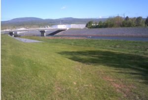
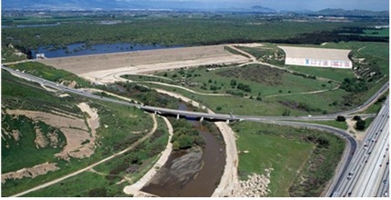
Prado Dam is located on the Santa Ana River, approximately 30.5 miles upstream of the Pacific Ocean. The dam is in Riverside County, California, approximately 2 miles west of the City of Corona. Portions of the reservoir are in Riverside County and San Bernardino County. U.S. Army Corps of Engineers (USACE), Los Angeles District (SPL), completed the existing Prado Dam in April 1941. The dam was then modified in 2008 to increase the reservoir storage and outflow capacity. Spillway modifications are necessary to complete the proposed increase in the Prado Dam reservoir storage capacity and to pass additional outflow discharge estimated from the 2020 Probable Maximum Flood (PMF) study.
The Aterra-Schnabel Joint Venture (ASJV), along with its subcontractor, Utah State University (USU), are scoped to plan, coordinate, develop, test, and perform physical model testing at the Utah Water Research Laboratory (UWRL). As a managing member of the Aterra-Schnabel JV, Aterra is developing design drawings to assist with physical model construction, reviewing modeling data, and assisting with report preparation, including QA/QC review. The following tasks are being performed as part of the project:
- Physical Modeling: Review of existing as-built information, 2D hydraulic modeling results, and topographic data in order to create 3D models of the existing approach conditions, spillway, and downstream topography. Preliminary design scenarios developed by USACE will be modeled to create desired testing scenarios. At model scale, evaluate constructability considerations to create design plans for USACE approval as well as details to assist USU with model construction.
- Model Testing and Data Collection: Testing and data collection will primarily be performed by USU with support from the JV. Model data collection includes water surface elevations, velocities, pressure, maximum scour depth, and videos of model performance. Aterra will assist with review and analysis of collected data to inform the design of the proposed spillway.
- Project Management: The JV is responsible for contract and project management, as well as the development and implementation of the Quality Control Plan.