Project Scope
Inundation mapping, hazard assessment, Emergency Action Plan (EAP) services, and decommissioning study relating to twelve Forest Service dams in Alabama, Arkansas, Kentucky, Georgia, and Virginia. Specific tasks for each dam included:
- Dam breach hazard assessment and inundation mapping for Lower Caney, Powhatan, Hale Lake, Ken Brad, Rock Creek, High Rock Lake, Sweetwater Lake, Choccolocco, Shady Lake, Narrow Creek, Payne Lake, and Terrapin Lake.
- New EAPs for Hale Lake, Ken Brad, Choccolocco, High Rock, Sweetwater, and Terrapin.
- An underwater inspection for Sweetwater Lake.
- Decommission and disposal study High Rock Lake
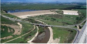
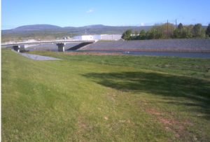
The dams are earthen and concrete arch structures of various hazard classifications. Hydrologic modeling was performed with HEC-HMS using multiple sub-watersheds to provide downstream hydrology. Two-dimensional (2D) hydraulic modeling was performed with HEC-RAS using the most recent LiDAR and landcover data. The breach hydrographs of the earthen structures were developed in WinDAM, a process-based erosion model, to provide more representative breach hydrographs. The breach hydrographs of the concrete structures were estimated using HEC-RAS. Detailed inundation mapping of nearly 100 miles was produced, indicating the extent of multiple breach scenarios per dam, comprehensive breach wave data at key points in the downstream valley, and the location of all structures in the downstream valley, differentiated by impact from breach and likelihood of occupation in event of a breach.
Hazard classifications and incremental consequences evaluations were enhanced by plotting the change in depth and velocity at impacted structures and crossings on USBR danger level (lethality) charts. This offered a clear measure of the increase in relative danger specific to types of different types of structures, crossings, and ages of individuals impacted by the breach.
The High Rock decommissioning report required large HEC-HMS and HEC-RAS models that included two other flood control dams; one upstream and one downstream of High Rock Dam. The with and without dam scenario were modeled and a detailed analysis was performed to assess changes to flood frequencies if the dam were removed.