
Project Scope
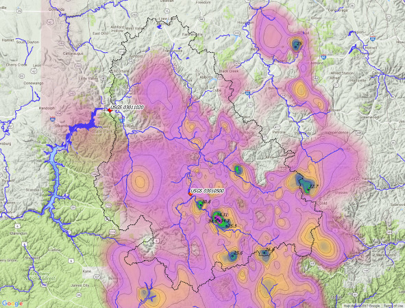
We completed an analysis of the July 1942 Smethport storm in north-central Pennsylvania, as part of the Probable Maximum Precipitation (PMP) Study for the Commonwealth of Pennsylvania, led by Applied Weather Associates (AWA). According to the National Oceanic and Atmospheric Administration (NOAA), the Smethport Storm of July 18, 1942, was a world-record-setting event for the 3-hour and 4.5-hour durations at 28.5 and 30.8 inches, respectively. A significant number of rainfall observations were reported; however, most were unofficial “bucket surveys” that have uncertainties in the total reported rainfall and limited temporal information; with only five or six scattered hourly gauges available to provide temporal information.
Our work involved a forensic investigation of the flooding that resulted from the storm to validate and refine observed precipitation data using observed flood data and a modeling combination of HEC-HMS, RiverFlow2D distributed hydrology/hydraulics (for areas receiving the highest amount of rainfall), and two-dimensional HEC-RAS for the main stem of Allegheny River. The analysis lead to refinements to the rainfall depth- area-duration data and temporal patterns for this important storm in the PMP development. Without an updated study, PMP data are typically obtained from one or more of a series of Hydrometeorological Reports (HMRs) prepared by the National Weather Service (NWS). Areas of the United States east of the 105th meridian are covered by HMR 51, which provides generalized depth-area-duration PMP data; with additional generalized temporal and spatial formation in HMR 52. The PMP study enables the use of site-specific hourly PMP data for areas as small as 1 km2 to evaluate the impact of the Probable Maximum Flood (PMF) on critical infrastructure.
The PMP study uses a storm-based method to transposition and maximizes extreme rainfall events in the region to create an envelope of depth-area-duration relationships unique to specific locations in Pennsylvania. Because it is storm-based, PMP depths for Pennsylvania, and much of the larger region covered by HMR 51, are greatly influenced by the exceptional magnitude of the July 18, 1942 storm in the region of McKean County and Potter County, and Cattaraugus County (New York State).